Galveston Pirate's Beach Weather Station
Located in Pirate's Beach, Galveston Texas
Latitude: 29 degrees 12' N -- Longitude: 94 degrees 5' W
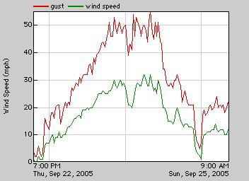
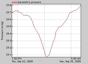
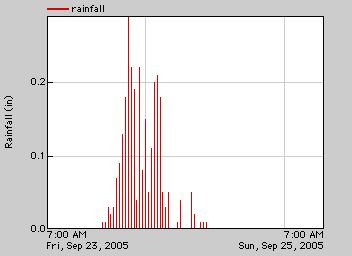
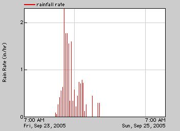
Hurricane Rita Weather Charts

Invaluable technical support provided by Rusty Ross

Home Page Previous Page Contact WebMaster

Wind Speed and Gust Level.
The wind speed is the 10 minute average, which tends to lower this measurement. The more interesting measurement is the red line showing the changing gust levels.

Also, there is a large house just to the north of the weather station and that may have tended to block some of the wind from Rita.

It is not clear whether this was much of an effect or not. However, given the very minor damage which seems to have been incurred at Pirates' Beach, it is likely that the winds did not really get much past 60 or 65 MPH anyway.


Barometric Pressure.
Note that the lowest pressure coincides closely with the maximum winds.

This chart is shown as inches of mercury. However, most news channels reported millibars.
Converting this chart to millibars shows that the lowest (lower is stronger) millibar level reached was 985.

This millibar level is consistent with the fact that the center of the storm was about 100 miles to the northeast.


Rainfall.
This is the rainfall levels over each ten minute period.

Note that the maximum rainfall over a ten minute period was a bit over 1/3 inch.
Total rainfall during Hurricane Rita was about 2.8 inches.

This constitutes significant but not extraordinary rainfall.


Rainfall Rate.
This shows the rate per hour of rainfall over each ten minute period.
The rainfall rates of 1 to 2.25 inches per hour is heavy but not extraordinary.


General Comments.
These charts show a significant, but not highly severe weather event.

Landfall of the center of Hurricane Rita was approximately 100 miles northeast of this weather station, which accounts for the moderate wind and rain effects.

The 5 -7 foot storm surge caused some beach erosion and removed much of the sand covering the Pirates' Beach dune-socks.

However, that surge level was low enough that the dune-socks prevented any home flooding.

Obviously, Galveston was extremely fortunate in the more northerly path that Hurricane Rita finally took.

This storm would have been catastrophic to the west end of Galveston island if the center had passed close by us.


Click here to view some Hurricane Rita photos.
Home Page Previous Page Contact WebMaster Top of Page Visits: